
A blog from Theo Witsell, Chief Ecologist and co-founder of SGI
As you travel east from the western edge of the SGI Focal Region (FIG 1), you become further and further removed from the time of the grasslands. It was on the northeastern edge of the Southeast that Euro-American settlers first began the slow process of obliterating the ancient grasslands, and the loss of these ecosystems spread from here to the south and west. Many of these grasslands were gone before they could be described, studied by naturalists, painted, or photographed. They are gone from our collective memory, a loss that has contributed to a lack of appreciation for their diversity and extent, even among scientists and historians.
FIG 1: The SGI Focal Region
But these grasslands leave behind clues to their existence, if we know how to read the landscape and interpret various lines of evidence. Here are a few of them:
Historical Maps and Surveys
Old maps and surveys are a treasure trove of evidence for southeastern grasslands. Early maps of the region, like this French map (FIG 2) from 1720, depict extensive areas of savanna in several areas not considered grassland today. Early land surveys are also excellent resources, especially in states that use the Public Lands Survey System (a standardized one mile by one mile survey grid divided into townships, ranges, and sections). Within the SGI Focal Region these states are Alabama, Arkansas, Florida, Illinois, Indiana, Louisiana, Mississippi, Missouri, Ohio, and Oklahoma.
Other states use different survey systems such as metes and bounds, Spanish and French land grants, etc. In many areas, the earliest of these surveys, and the maps made from them, provide a peek into what the landscapes were like prior to Euro-American settlement. In the states using the Public Lands Survey System the earliest surveys were done in the late 1700s to early 1800s, and there are records in some areas from even earlier.
FIG 2: A French map of the Southeastern United States from 1720 showing “Savana Land and Good Pasture Ground” over what is now Kentucky and Tennessee, and “Savana” in west-central North Carolina, southern Georgia, and northern Florida.
Early plat maps from the Government Land Office (GLO) surveys often explicitly mapped prairies and other grasslands (FIG 3), and these have been digitized for many areas in recent years allowing ecologists to overlay maps of grasslands from 200 or more years ago. Other information can be gleaned from the surveys themselves, such as comments like “set corner post as no trees convenient to mark this corner.” Similarly, surveys in grassland areas in other states, such as this (FIG 4) 1790s survey of a tract near Crab Orchard, Tennessee, make repeated references of having to set stakes at corners.
FIG 3: A General Land Office (GLO) plat map from the early 1800s showing a prairie of more than 1,000 acres in extent along the Arkansas River near Van Buren, Arkansas.
FIG 4: A Revolutionary War Land Grant survey from the 1790s shows stakes used to mark most of the property corners, an indication that trees were absent or so sparse as to be inconvenient to serve as “witness trees.”
Historical Quotes
Digging into the historical records can be a satisfying exercise for an ecologist. Early accounts of the Southeast are full of quotes describing natural grasslands and the biodiversity they supported. Here are a few of my favorites from places I’ve traveled and worked:
“Here a vast prairie opens to view, like a shorn desert, but well covered with grasses and herbaceous plants.” – Thomas Nuttall, describing the southern tip of the Grand Prairie, a few miles north of Arkansas Post, Arkansas, 1819
“The top of the mountain is...a vast upland prairie, covered with a most luxuriant growth of native grasses, pastured over as far as the eye could see, with numerous herds of deer, elk and buffalo, gamboling in playful security over these secluded plains.” – Francis Bailey, describing Cumberland Mountain (Tennessee) in the 1780s
“Our route was continued through prairies, occasionally divided by somber belts of timber, which serve to mark the course of the rivulets. These vast plains, beautiful almost as the fancied Elysium, were now enameled with innumerable flowers, along the most splendid of which were the azure Larkspur, gilded Coreopsides, Rudbeckias, fragrant Phloxes, and the purple Psilotria. Serene and charming as the blissful regions of fancy, nothing here appeared to exist but what contributes to harmony.” – Thomas Nuttall, describing the area near the Poteau River on the Arkansas/Oklahoma border, 1819
“It would be difficult to imagine anything more beautiful. Far as the eye could reach, they seemed one vast deep-green meadow, adorned with countless numbers of bright flowers springing up in all directions ... only a few clumps of trees and now and then a solitary post oak were to be seen...Here I first saw the prairie bird, or barren-hen…. Here the wild strawberries grew in such profusion as to stain the horses hoofs a deep red color.” – Rueben Ross, describing the Pennyroyal Plain Prairie of southern Kentucky and northern Tennesssee, 1812
“The country passed over yesterday, after leaving the valley of the White River, presented a character of unvaried sterility, consisting of a succession of limestone ridges, skirted with a feeble growth of oaks, with no depth of soil, often bare rocks upon the surface, and covered with coarse wild grass; and sometimes we crossed patches of considerable extent, without trees or brush of any kind, and resembling the Illinois prairies in appearance, but lacking their fertility and extent. Frequently these prairies occupied the tops of conical hills, or extended ridges, while the intervening valleys were covered with oaks…” – Henry Rowe Shcoolcraft, describing the dolomite glade country of the White River Hills near the Missouri/Arkansas border, 1818
Old Place Names
When it rains at my house in Little Rock, water runs down the hill into a stream called “Grassy Flat Creek,” so named for the open oak flatwoods that used to exist along its lower reaches before they were replaced with neighborhoods and shopping centers in the 1960s. There are many, many sites like this across the Southeast, with names that hint at their grassland heritage: towns like Barren Plain, Tennessee and Prairie Grove, Arkansas; places like Big Barren Creek and Bald Scrappy Mountain in the Ozarks; Glade Branch and Grassy Cove in the Cumberland Plateau, and there are more Prairie Creeks across the Southeast than you can shake a clump of big bluestem at. These names often go back to the earliest English-speaking settlers or explorers who saw a very different landscape than we see today.
Presence of Conservative Grassland Plant Species
Certain plant species are found only in high quality grassland remnants. We call these “conservative heliophytes” or “conservative grassland obligates” and their presence is a sure sign that an area is a natural grassland remnant. Plants like Oklahoma grass-pink orchid (Calopogon oklahomensis) (FIG 5), American chaffseed (Schwalbea americana) (FIG 6), and blue-hearts (Buchnera americana) (FIG 7) are examples of these grassland indicators. It’s safe to say that if you’ve found such species you are standing in a grassland remnant.
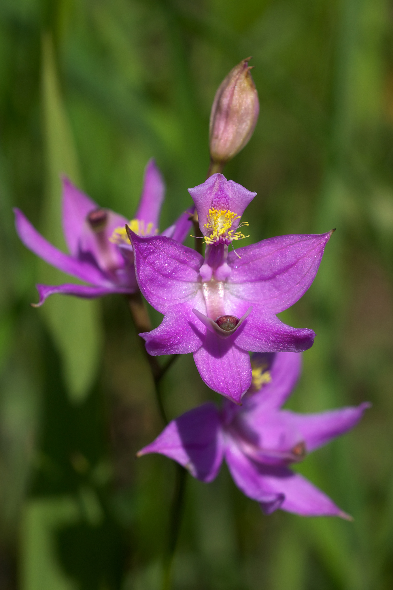


FIG 5 left: Oklahoma grass-pink orchid (Calopogon oklahomensis), a species of ancient prairie remnants, occurs primarily in southeastern grasslands west of the Mississippi River, but is also known from scattered sites in Alabama and Mississippi, and (historically) in Georgia and Tennessee. Photo: Eric Hunt.
FIG 6 center: American chaffseed (Schwalbea americana) is a very rare fire-dependent grassland species known primarily from the outer Coastal Plain pine savannas but is also known from a few historical records from inland grasslands in Kentucky and Tennessee. Photo: dogtooth77 (via iNaturalist).
FIG 7 right: Blue-hearts (Buchnera americana) is a widespread, but increasingly uncommon species known from a wide variety of grasslands across the Southeast. Photo: Eric Hunt.
SGI is developing a series of volunteer projects on Notes from Nature that will digitize the label information from herbarium specimens of conservative grassland plant species in our region. Once these specimens are georeferenced (assigned latitude and longitude coordinates based on the locality information on their labels) they can be used to map the presence of historical grasslands.
Similarly, we can identify remnant grasslands (even fairly degraded ones) on the landscape today by the presence of these species. SGI is currently working on a project funded by the Tennessee Department of Transportation to identify areas along Tennessee state highways that support remnant grassland vegetation. Once identified, these areas can be managed in a way that will benefit these grassland plant communities and will serve as seed sources for future habitat restoration.
Nebkhas or Pimple Mounds
A conspicuous feature of many grasslands in the western part of the SGI focal area (west of the Mississippi River) are concentrations of scattered lens-shaped mounds, from three to five feet high and 30 to 100 feet across (FIGS 8 and 9). The technical names for these mounds are nebkhas or coppice dunes, but they are more frequently known as pimple mounds, prairie pimples, prairie mounds, or Mima mounds*. Their origin has been the subject of much debate in the past but they are essentially wind-blown dunes that accumulated around clumps of vegetation during drier climatic periods in the past. They are nearly always found on flat to gently rolling plains with some sort of restrictive layer in the soil like shallow bedrock or a clay hardpan. Basically, at some point in the past, these plains were so sparsely vegetated that the soil blew from barren areas and gathered around vegetation such as shrub thickets. As the climate eventually moderated these dunes were stabilized by grasses and have persisted to the present day.
FIG 8: A GLO plat map (above) from the early 1800s showing a “wet prairie” intercepted by a survey section line 5.5 miles southwest of Ashdown, Arkansas paired with a modern-day aerial photo (below) of the same area showing a wet nebkha field (today a cattle pasture).
FIG 9: Detail of nebkha field in Fig. 8. Note the extensive network of ditches installed in an attempt to drain the area during the wet season.
These nebkha fields often have wonderful microhabitat diversity packed into a small area – with well-drained mounds surrounded by seasonally wet flats dotted with networks of swales and depression wetlands. They are also common in flatwoods communities west of the Mississippi, which were more open historically and often still support a grassland flora on the ground if they are open enough.
* The term “Mima mounds” is more accurately applied to superficially similar features at Mima Prairie in Washington State, which may have been formed by different processes.
Topographic Roughness/Fire Compartment Size
Because fire is such an important process in the maintenance of most of our Southeastern grasslands, landscape factors that influence the frequency, intensity, and scale of fire also play an important role. This is most obvious in the inverse relationship between the number of natural fire breaks (large streams and rivers, bottomland forests, rugged terrain, etc.) in a landscape and the historical presence of large grasslands. Simply put, large flat to gently rolling areas without a lot of abrupt topographic breaks (like ravines or bluffs) or larger streams and rivers, are more likely to have supported grasslands historically. Or put another way, the larger a natural “fire compartment” on the landscape the higher the probability that a given point within it will experience a fire in a given year.
For example, on the so-called “table lands” of high plateau surfaces such as the Cumberland and Ozark Plateaus, fires, whether ignited by lightning or humans, could burn without interruption over large areas for weeks or sometimes months on end. Similarly, karst plains such as the Pennyroyal Plain of Kentucky and Tennessee, which are pockmarked with sinkholes and don’t have many surface streams, also amount to large fire compartments with few natural fire breaks in the form of bottomland forests. Other less stark examples are the ancient, elevated stream terraces along rivers in the Coastal Plain which historically supported extensive pine savannas or the broad valleys of the Ridge and Valley Ecoregion, which historically supported many grasslands.
Using clues like these, and possibly others yet to be discovered, SGI is prioritizing sites where we can restore southeastern grasslands and bring them back into our collective consciousness.