

Sumter Farm & Stock Company: A Private-Lands Model for Prairie & Savanna Restoration in the Alabama Black Belt
from:


““The Southern Grassland Biome...is probably the richest terrestrial biome in all of North America. To understand, cherish, and preserve the great natural heritage of the Southern Grassland Biome should be a priority goal in America’s environmental movement.””

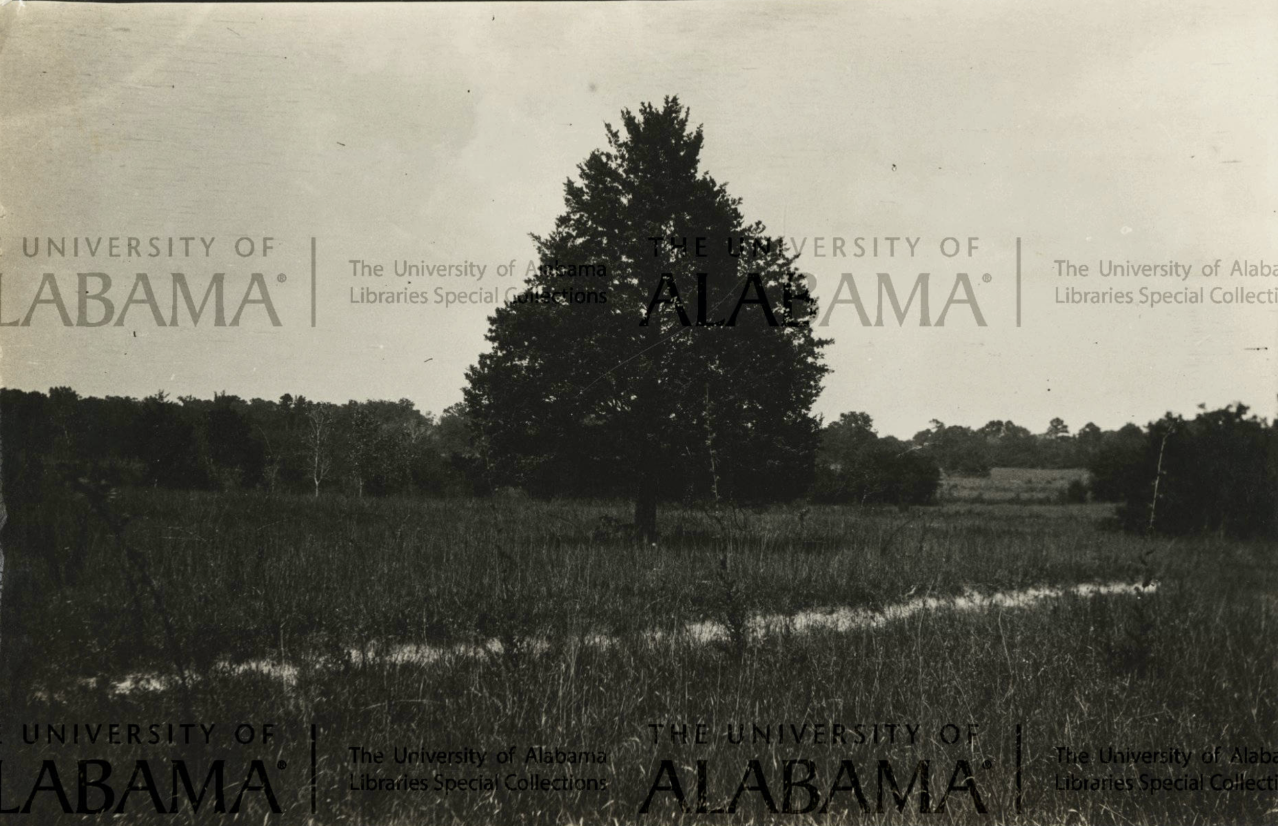
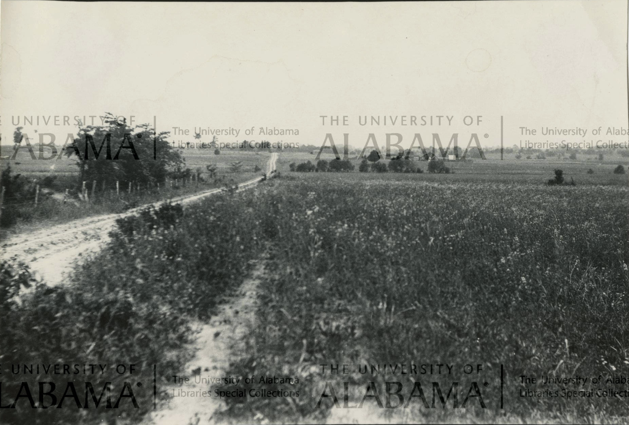
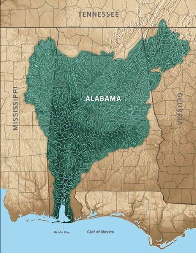
The Black Belt can be seen from space. Prior to 1800 it was covered in prairies, savannas, and open woodlands of more than 1 million acres. More than 99.9% of this once amazing ecosystem has been destroyed. Sumter Farm & Stock Company, an 11,000-acre farm in Sumter Co., Alabama, preserves one of the most significant chunks of the Black Belt and its location is shown in red.
The Black Belt Prairie Ecoregion can be seen from space stretching almost 350 miles from southwest Tennessee in a crescent south and east across Alabama, reaching only about 35 miles wide at its widest point. About 200 years ago, this region was home to one of the largest grasslands in the South, encompassing more than one million acres of open prairies, chalky barrens, canebrakes, and sparsely treed oak and oak-pine savannas. These grassland ecosystems were maintained by a combination of fire, grazing, and the challenges to tree growth presented by dense clay shrink-swell soils. These grassland types graded into open, grassy oak-hickory woodlands and rich forests on bottomlands, slopes, and bluffs.
As Mississippi and Alabama became states in 1817 and 1819, respectively, and the Chickasaw, Choctaw, and Creek Indians were pushed out, the Black Belt was destined to change forever. The name Black Belt is a double entendre but the different meanings are inextricably linked. On the one hand, the region is named for its dark black, calcareous and fertile topsoil that was perfect for growing cotton. Unfortunately, its second meeting is derived from the fact that the region was home to the largest concentration of African-American slaves in the 19th century and the dash to cultivate as much of that fertile plowable ground as possible in the slave-driven cotton economy, led to the rapid elimination and degradation of most of the prairies in just a few decades after settlement.
With little knowledge of sound farming practices such as crop rotation and cover crop usage, repeated cultivation led to precious topsoil eroding away, exposing the off-white clay, marl, and chalk subsoil. Worn-out fields and pastures were “improved” with non-native grasses that now cloak the landscape. Abandoned fields not used for pasture or crops succeeded into cedar thickets and later became cedar-hardwood forests. Likewise, savannas and open grassy woodlands became dense, closed-canopy forests without fire. Loss of bison and elk, followed by two centuries of erosion, misuse, overgrazing, and fire suppression has resulted in the loss of 99 percent of the region’s original grasslands and the open woodlands becoming dense and crowded.


The remaining 1 percent
The remaining one percent clings to life in the 21st century mostly in powerline corridors and along roadsides. Unfortunately, the single Tennessee remnant discovered in the 1950s is limited to a couple of dozen prairie species on a few square meters of rural roadside banks and in effect the Black Belt ecosystem is extinct in Tennessee. Alabama and Mississippi are and have always been the most important states for the Black Belt. In Alabama, Al Schotz and Michael Barbour of the Alabama Natural Heritage Program, based at Auburn University, have mapped and inventoried the remaining patches of Black Belt prairie and presented their findings in a 2009 report. In their multi-year study, they determined how much prairie exists, the quality of remaining prairie acreage, where the greatest clusters of prairie are located, and how rare birds, reptiles, and mammals utilize those prairies. They mapped 15,509 acres of prairie remaining across the Alabama Black Belt and identified Sumter County, Alabama as containing the most remaining prairie, with 1,330 acres. They also noted that 15 percent (88,000 acres) of Sumter County had “prairie soils.” In total, they identified 10 significant clusters of prairie in Alabama, including a large cluster in southeast Sumter County. Unfortunately, such intensive mapping and prioritization does not yet exist for the Mississippi Black Belt. Within that state, important remnants are the 105-acre Osborn Prairie (also known as 16th Section Prairie) in Oktibbeha County and the 100-acre Pulliam Prairie in Chickasaw County. The U.S. Forest Service also is actively restoring a several hundred acre tract in north Mississippi.
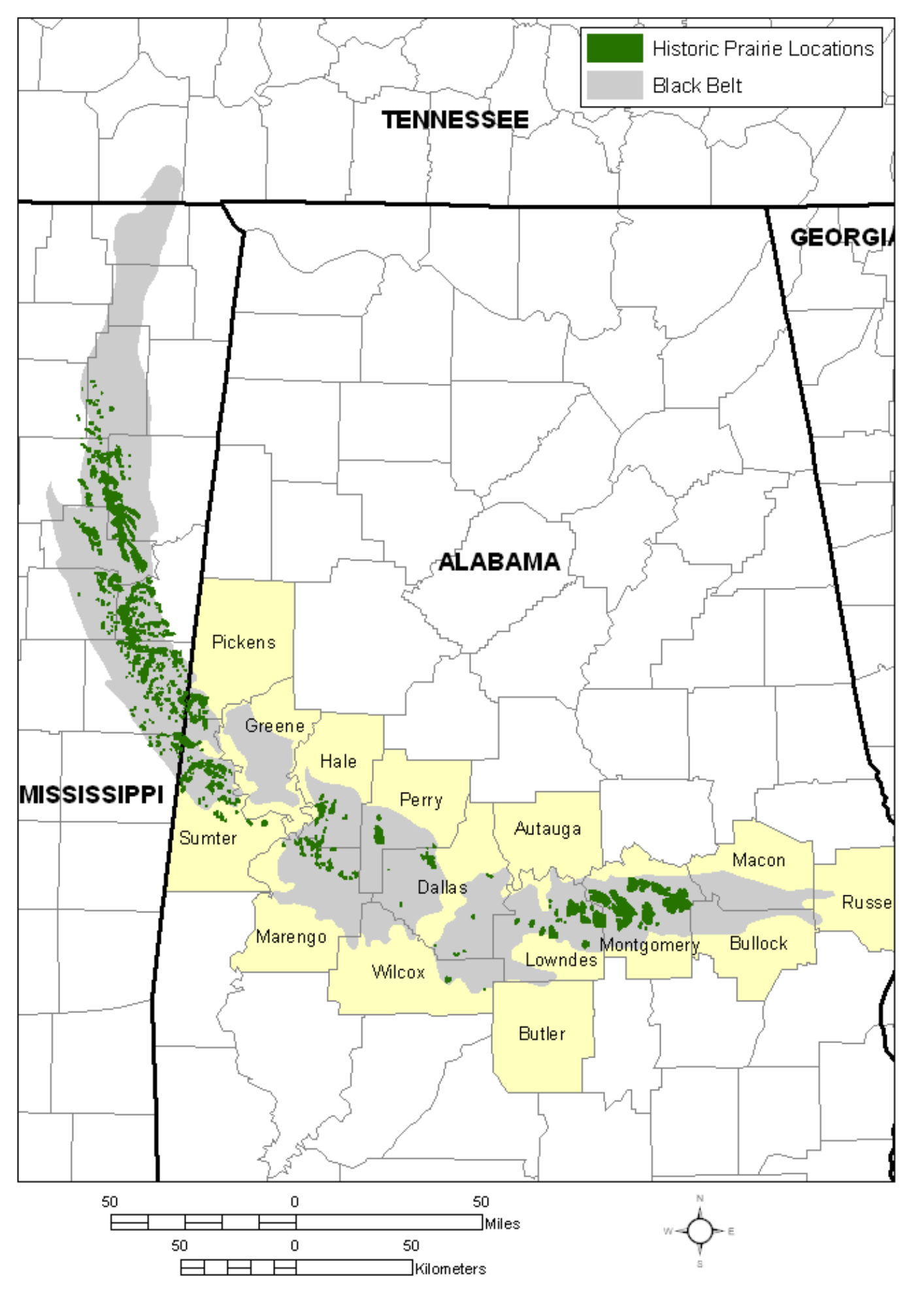
Map of the Black Belt Prairie Ecoregion by Al Schotz and Michael Barbour (2009) from their report titled an “Ecological Assessment and Terrestrial Vertebrate Surveys for Black Belt Prairies in Alabama.” Historical locations of Black Belt prairies are shown in green from the mapping work of John Barone (2005) based on 1830s land survey data.

Close up showing the historical distribution of Black Belt prairie in Alabama based on 1830s land survey data (Barone 2005).

Historic prairies from 1830 land surveys shown in gray (Barone 2005). Remnant prairies as of 2005 mapped by Schotz & Barbour (2009) according to quality: low, moderate, high, significant.

Google Earth map on right showing location of Sumter Farm & Cattle Co. On the left, the farm (outlined in yellow) is shown on the map produced by Schotz & Barbour (2009) showing remnant Black Belt Prairies in west-central Alabama. Note that although no prairies were identified on the 11,000-acre farm by Schotz & Barbour’s study, our preliminary 2-day survey found prairies and savanna that high-quality with rare species and of high regional significance.
None of the large remnants found today offers the kind of grand scenes once described by William Bartram in 1775 in present-day Montgomery, Alabama. Artist Philip Juras captured Bartram’s words and re-created what these prairies looked like as they extended to the horizon across the rolling plains of south Alabama. The Black Belt was not like the Great Plains. Across the larger landscape, the Black Belt was not a single large open prairie but rather was “a dense archipelago of prairie ‘islands’ imbedded in a matrix of woodland and forest (Barone 2005). The prairies proper, which were “largely treeless, though surrounded by forest and often with small woodlands within them, usually on hilltops or ridges,” only covered about 345,000 acres (Barone 2005). However, Perkins (in Wright 1882) wrote that in 1825 the Saunders family of McNairy County, Tennessee, found “A virgin soil of great fertility, landscapes of marvelous beauty made up of green savannas...” The “treed” portion of Black Belt, the savannas and open, grassy woodlands, likely pushed the total grassland acreage over one million acres.
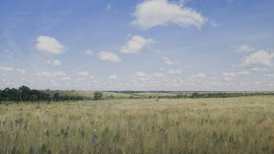
The virgin Black Belt Prairie as it likely appeared in 1775 and was described by naturalist William Bartram from site of present-day Montgomery, Alabama. (Oil on canvas by Philip Juras)

Barone (2005) mapped the historical prairie patches that were identified on 1830 government land surveys. Onto this he overlaid historical references to different prairie patches by various early explorers, settlers, missionaries, French officers, and naturalists. James Nance visited the prairies in northwestern Sumter County in 1832.
America’s Amazon
Part of what made the Black Belt so beautiful and biologically diverse is the fact that the landscape was a mosaic. Always close by to the prairie were savannas, woodlands, forests, wetlands, and streams, which combined to make the Coastal Plain of Alabama one of the richest sites on Earth. In 2015, this region of Alabama was included in the designation of the world’s newest global biodiversity hotspot—Southeastern U.S. Coastal Plain Hotspot—by the Critical Ecosystem Partnership Fund—a designation that came following a publication led by Dr. Reed Noss, author of Forgotten Grasslands of the South and current Chief Science Advisor for SGI.
A recent article by journalist and film producer Ben Raines in the LA Times likened much of Alabama to “America’s Amazon.” Raines paid homage to the wealth of natural streams and wetlands (especially bottomland forested wetlands) found in Alabama and was quoted in an NPR interview stating, “There are more species of fish, turtles, snails, salamanders, crawfish and mussels here than any other river system in America." Raines points out the need to raise awareness about Alabama’s tremendous natural assets. He notes that it is critical to protect the “hot zone…where aquatic creatures and land creatures…interact." He adds, that "If we don't protect it, if we build on top of it, and live on top of it, or destroy it through logging, what have you, we lose that."
We agree those edges are important to protect, and they extend far upriver from the Mobile-Tensaw Delta. In rivers like the Alabama, Black Warrior, Coosa, Sipsey, Tallapoosa, and Tombigbee, and numerous others, the pollutants trickle in to the streams from adjacent cotton fields, pasture run-off, chemical spills, urban sources, and pollution from factories such as the Tyson Chicken Factory which recently polluted the Locust Fork of the Warrior River. But, what Raines didn’t cover is that it isn’t just about protecting these upstream regions from “logging”—so much of what needs to happen is restoring ecosystems along rivers like the Noxubee to what they were like historically, which included prairies and savannas, in addition to the often heralded forests and wetlands. Failure to recognize the millions of acres of Alabama that were once grassland is yet another reason why Reed Noss appropriately termed them the “Forgotten grasslands of the South.” They are still being forgotten as a key components in American conservation, even though famous Alabamian, Dr. E.O. Wilson of Harvard University, says that these Southern grasslands “should be a priority goal in America’s environmental movement.”


Photos of the some of the best remaining Black Belt Prairie remnants. Old Cahawba Prairie, Dallas Co., Alabama (left), Osborn Prairie, Oktibbeha Co., Mississippi (middle), and Pulliam Prairie, Chickasaw Co., Mississippi (right).
While Southern grasslands were much smaller than those in the Midwest, what they lack in size they make up for in biodiversity. In the 1980s, Dr. Sidney McDaniel at Mississippi State University (MSU), and students, studied Osborn Prairie, located largely within the right-of-way of a Tennessee Valley Authority powerline corridor. They found that this little prairie patch is home to many rare species found almost nowhere else in the region. It was particularly rich in western species that are found primarily west of the Mississippi River such as Yellow Plume (Neptunia lutea), Prairie Pleatleaf (Nemastylis geminiflora), and Great Plains Ladies Tresses Orchid (Spiranthes magnicamporum).

Neodactria oktibbeha, a praire moth known from two prairies in the world, one in Mississippi and one in Minnesota and nowhere in between. It is named for Oktibbeha County, Mississippi where it was discovered at Osborn Prairie.
Later, staff at MSU’s Mississippi Entomological Museum began to study the insect diversity at Osborn, discovering unusually diverse assemblages of moths, bees, ants, and grasshoppers. They discovered a new species of moth, Neodactria oktibbeha, known only from that one prairie and from a single prairie in Minnesota more than 1,000 miles away, and nowhere else on Earth. A follow-up study found 90 species of bees at Osborn Prairie, in less than 100 acres. Incredibly, the Black Belt is home to about 1,000 species of moths.
Meanwhile other notable discoveries continued to be made at Old Cahawba Prairie in Dallas County, Alabama. In 2001, botanist Jim Allison named a new species of a sunflower relative, Sticky Rosinweed (Silphium perplexum). This 6-7 ft tall plant is known only from a couple of prairies in Dallas and Perry counties. About ten years ago, Pulliam Prairie was discovered north of Starkville yielded new species of Black-eyed Susan (Rudbeckia terranigrae). In 2013, Dr. Brian Keener, University of West Alabama, and Zach Irick and Dwayne Estes (both with Southeastern Grasslands Initiative, based at Austin Peay State University) discovered a new species of leatherflower (Clematis) known only from “prairie woods” in the Black Belt near Demopolis and Livingston. These discoveries reveal how unique each remnant prairie is. For example, some of the important species found at Old Cahawba are not at Osborn and vice versa. Therefore, study of each large remaining remnant has a decent chance of leading to significant discoveries, sometimes of totally new species unknown to science.
Sticky Rosinweed (Silphium perplexum) was discovered in the late 1990s as a new species and named in 2001. It is known from just 3 counties in Alabama in Black Belt Prairie and nowhere else in the world. It highlights how there is still more to discover in this overlooked part of the Southeast. Photo by: James R. Allison

Rudbeckia terranigrae (Black Belt Black-eyed Susan) was discovered following the study of the Pulliam Prairie in Chickasaw County, Mississippi by Campbell and Seymour (2011, 2012). It had been overlooked for decades and confused with other common species. Photo by: Dwayne Estes

This new undescribed species of Clematis (Black Belt Leatherflower) is under study by Brian Keener, Zach Irick, and Dwayne Estes. It is known only from “prairie woods” in the Black Belt of west-central Alabama where originally discovered near Demopolis. It could be on the farm waiting to be discovered. Photo by: Dwayne Estes.
The Black Belt has been so heavily modified that it is rare to find sizable tracts of prairies that are off the radar of the conservation community. But that’s exactly what happened in fall 2020 when the owners of the 11,000-acre Sumter Farm & Stock Co. contacted the Southeastern Grasslands Initiative. Mitchell Bell mentioned that he and his family wanted to know if SGI had an interest in coming down to see the property. We at SGI get such requests all the time and we love interacting with private landowners. But so many times we are disappointed when upon our visit we find that what the landowners thought was something special, is often ecologically highly disturbed and not special at all.
Given the losses that the Black Belt region has sustained, and the fact that the few large prairies in existence seemingly were already known, it didn’t seem likely upon first consideration that there would be much of significance. But, Mitchell shared photographs of species he found on the farm which showed rare species that grow only in high-quality grassland habitats. We realized with just those couple of photographs that the farm had excellent potential. Upon studying aerial maps ahead of our visit, we could see patches of prairie and we grew excited about the possibilities of what the farm could potentially hold. When we consulted Schotz and Barbour’s (2009) report it showed a couple of prairie patches adjacent to but not on the property that were designated as low quality. Still we were intrigued to visit and see it for ourselves and make firsthand observations.

Theo Witsell, SGI Chief Ecologist, and Dr. JoVonn Hill, Mississippi Entomological Museum, stop to examine plants and insects.
“Whoa! Look at this this!!!”
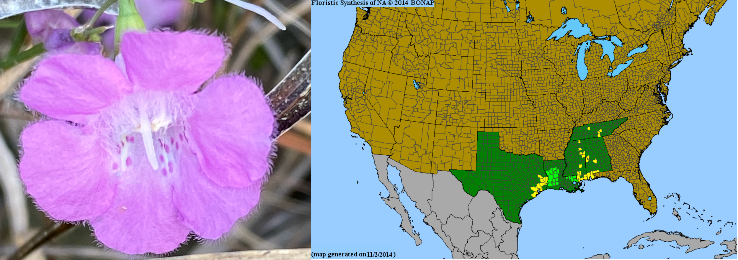
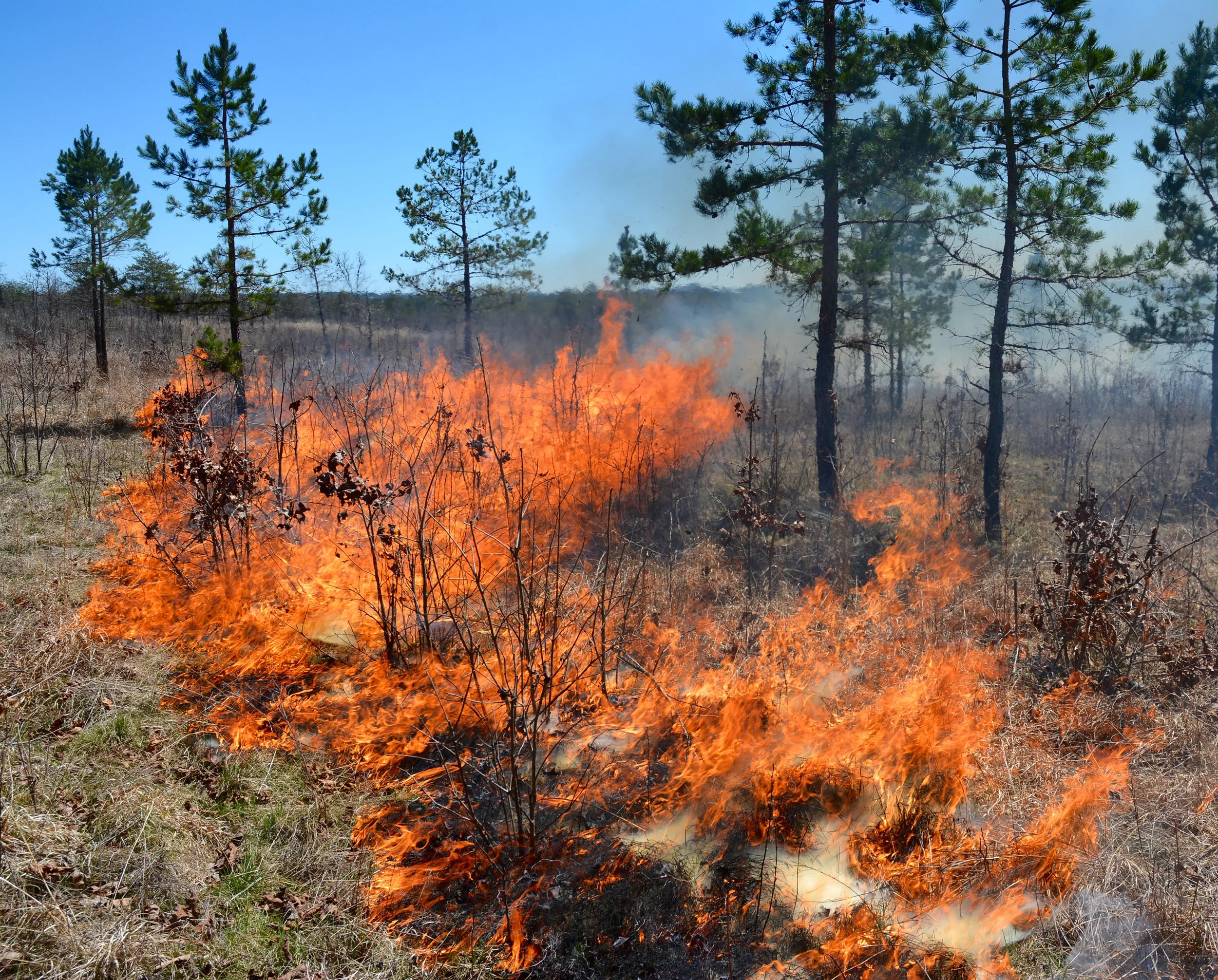
On October 26-27, 2020, we [Dwayne Estes and Theo Witsell (SGI), JoVonn Hill (MSU), Brian Keener (UWA)] visited the farm with the family and were impressed by what we found. During the course of the two day visit, we observed a rare deep-soiled tallgrass prairie remnant, hundreds of acres of pine-oak savannas and woodlands, incredible flatwoods, rich forested bluffs, and one of the prettiest rivers in the Coastal Plain, the Noxubee, one of those precious upper tributaries of “America’s Amazon.” Even though it was late in the season, we found significant and unexpected finds such as the rare Earleaf False Foxglove (Agalinis auriculata), not previously known from Sumter County and only known from a handful of sites in all of Alabama.
We created the Biodiversity of Sumter Farm and Stock Co., Alabama project on iNaturalist to track our finds. Over two days, the seven of us recorded our observations in the project. To date, we have documented 370 observations of 264 species. Based on the size of the farm and diversity of habitats (grasslands, savannas, forests, woodlands, wetlands, agricultural) we believe the property probably supports 500-600 plant species, perhaps more. Thanks to management and restoration by the family over the past half-century, we were encouraged by the variety and size of high-quality habitats and we think there is high likelihood of more rare plant and animal species tracked by the Alabama Natural Heritage Program and U.S. Fish and Wildlife Service. Due to the late date and short duration of our survey we knew that further study would be needed to document the biodiversity and habitats of the farm.

The nexus between culture & conservation
This map from 1860 shows percentages of slaves by county with the darkest counties having slave populations comprising at least 70 percent of the county population. The Alabama Black Belt is one a few major slavery centers in the Southeast. Black Belt Prairies were widely obliterated during the 19th century.
While Alabama has a long history of under-prioritizing conservation, it has a rich cultural history, some much celebrated and some representing dark periods of the past. In Raines’s interview, he mentions that the last slave ship that brought “enslaved Africans to America was found" by Raines himself in the Mobile-Tensaw river system. There is a poignant connection that becomes clearer when we stop and consider the nexus between the natural history and cultural history of Alabama that is often untold. The nexus between these two histories is also deeply connected to present conservation issues such as water quality. Much of the water quality issues facing the Mobile-Tensaw watershed arise from agricultural pollution of interior rivers. What is one of the greatest agricultural centers in all of the eastern U.S.? It is the Black Belt, home to one of the largest centers of cotton production in the 19th century. This cotton was worked by slaves who had been brought into South Alabama via the same waterway, many would come to toil in the hot fields of the Black Belt of Alabama and Mississippi. They couldn’t help it, but in their forced labor, the prairies vanished, topsoil vanished, species vanished, and what came after was a greatly depleted human and ecological aftermath.
Too many times in the 100+ year history of Southern conservation have well-intending individuals like Raines mistakenly left out any mention of grasslands. In heralding the impending loss of America’s Amazon—the Mobile Tensaw River System, Raines and others have apparently forgotten to mention that we have already lost 99 percent of a former “grassland Amazon”—the Black Belt, the Longleaf Pine Savannas, the Coosa Prairies, the Cumberland Plateau Shortleaf Pine-Oak Savannas, all of which formed the majority of the headwaters regions for these rivers. But now, as we worry about the new and fast-growing “dead zone” off the coast of Mobile, it is time we build one step further on Raines’s ideas. It is true we must think about where the land meets the water, but importantly we must prioritize, as E.O. Wilson suggests, the grasslands, which for the past 200 years have been utterly abused and neglected, while forests, forested wetlands, streams, and coastal environments have gotten the majority of conservation focus and funding. Private properties such as Sumter Farm & Cattle Company can play important roles in reshaping how we look at conservation in Alabama and conserve our precious remaining natural resources.
One of the most significant properties in the black belt
Before leaving the farm, we sat down with the family and expressed how inspired we were by the excellent conservation work that they had accomplished all by themselves. In our professional opinions, the property has immensely significant natural resources, ranking it among the top known sites in the Black Belt and due to its size, quality, and restoration potential, we at SGI would ranks it one of the most significant “prairie properties” in the South.
We discussed with the family their needs and wishes for the farm. They expressed a desire to continue to use about one-third of the farm for cattle grazing and hay production, one-third for timber production, and one-third for recreation (hunting, wildlife viewing, hiking). The family expressed interest in how they can build capacity on their existing conservation practices to enhance the use of more prescribed fire, invasive species treatment, selective timber harvests, and improvement of cattle grazing and haying lands to restore prairie and savanna habitats.
Funding for habitat management is often tied to the presence of rare species, especially rare birds, bats, mussels, fish, salamanders, reptiles, and crayfish. Presence of rare animals is tied to high-quality habitat, which is in turn determined by plant species that form natural communities and provide cover, food, and nectar, or what we at SGI like to call “groceries on the ground.” Given that we observed hundreds of acres of high-quality habitat with numerous highly conservative and rare species of plants, it makes sense that there is excellent potential habitat for additional rare species to be discovered. But in order to determine this, a thorough study of the farm’s biodiversity is needed along with identifying and mapping the various habitat types. This will help landowners visualize the landscape and prioritize future conservation efforts. Such a baseline study will be essential to the development of a restoration, management, and conservation plan to help inform short- and long-term conservation needs. This multi-faceted plan will help ensure that the farm’s natural resources remain intact through future generations.
Such an investment will also help identify conservation funding opportunities from private, federal, and state grants such as the National Fish and Wildlife Foundation (NFWF), USDA Natural Resources Conservation Service (NRCS), and U.S. Fish and Wildlife Service Partners for Fish and Wildlife Program. Finally, this investment will allow the Farm to hold a special place as regional conservation efforts in the Black Belt continue to build and involve education and outreach, community engagement, regional conservation planning and collaboration, green economic opportunities, ecotourism, and market-driven conservation strategies.
We appreciate the family’s consideration of this proposal from SGI and our partners. We welcome the opportunity to work together to tell “An Untold Story of American History & Conservation.” SGI is on a mission to “Chart a New Course for Conservation in the 21st Century” by elevating grasslands conservation as a “priority goal in America’s [and Alabama's] environmental movement.”
objectives
For restoration to succeed in an effective and cost-efficient manner it is imperative to understand what resources are present on the farm in order to determine what needs to be enhanced, restored, reduced, or eradicated. SGI partnered with locally-based experts at UWA and MSU in developing this collaborative proposal. Collaboration is key and we are excited about potentially working side-by-side with other conservation organizations in the state and region such as USDA NRCS, US Fish and Wildlife Service, Alabama Natural Heritage Program, and Alabama Audubon.
Our proposed work will consist of three components:
Describe and map habitat types
Document biodiversity
Develop a restoration, management, and conservation plan

I. Describe & Map Habitat Types
During our October 2020 visit, we barely explored the 11,000-acre farm, but the bits we saw were amazing as shown in the photo collage below. In our proposed work we will describe and map these and other habitats on the farm (including disturbed habitats that may be restorable), determine acreage of each type, and rank the different habitats in terms of quality and potential for restoration.
We will bring our expertise and abilities to read the clues of the land to map habitat types—the different kind of prairies, savannas, woodlands, forests, and wetlands—using the experience we’ve developed for other large properties, including the 900-acre farm of Senator Bill & Tracy Frist in Roanoke, Virginia, the 800-acre Stones River Bend Park in Nashville, Tennessee, and the 5,000-acre Coal Creek Farm in Crossville, Tennessee. Prior to creating SGI we also mapped the habitats across 25,000-acres associated with the 15-mile-long Ocoee River Gorge east of Chattanooga for the U.S. Forest Service and Tennessee Department of Transportation. Mapping the 11,000-acres at Sumter Farm & Stock Co. is a foundational step toward developing a short- and long-range conservation vision for the farm. This portion of the work would be led by SGI’s Chief Ecologist, Theo Witsell.


II. Document Biodiversity
Our team will partner with Alabama Audubon, U.S. Fish and Wildlife Service, and Alabama Geological Survey who have shown interest in helping to document birds, mammals, reptiles, amphibians, fish, crayfish, and mussels. We bring to this team a focus on plants and insects. Plants shape the habitat, provide seeds and nectar for wildlife, and together with insects form the basis of the food chain. They are useful as “storyteller species” and they serve as barometers for understanding the health and management needs of the land. The family and farm guests can help with documenting species. Knowing which species are present is key to sound land management.
Our team includes some of the top experts in biodiversity exploration in the Southeast. In particular, SGI would rely on its new partnerships with the University of West Alabama (UWA) and Mississippi State University’s Mississippi Entomological Museum (MEM) to represent SGI with local expertise. Dr. Brian Keener and a UWA graduate student will lead the floristic study. Dr. Keener is recognized as the leading botanist in the Alabama-Mississippi region and is Curator of the Herbarium at UWA and the Alabama Plant Atlas, which is the primary source of information on the 4,233 known vascular plant species of Alabama. Dr. JoVonn Hill and his team at MEM are the recognized leaders in the study of insect biodiversity in the region. He serves as interim director of MEM and curates the 3rd largest insect collection in the Southeast. Specimens of plants and insects will be collected and deposited in the regional museums at UWA (plants), MEM (insects), and at SGI headquarters at APSU (plants).

Theo Witsell, Southeastern Grasslands Initiative, laying down on the job, photographing a rare orchid in the prairie.

Brian Keener, University of West Alabama, presses a specimen of the rare Barrens Silky Aster to be preserved in the herbarium.
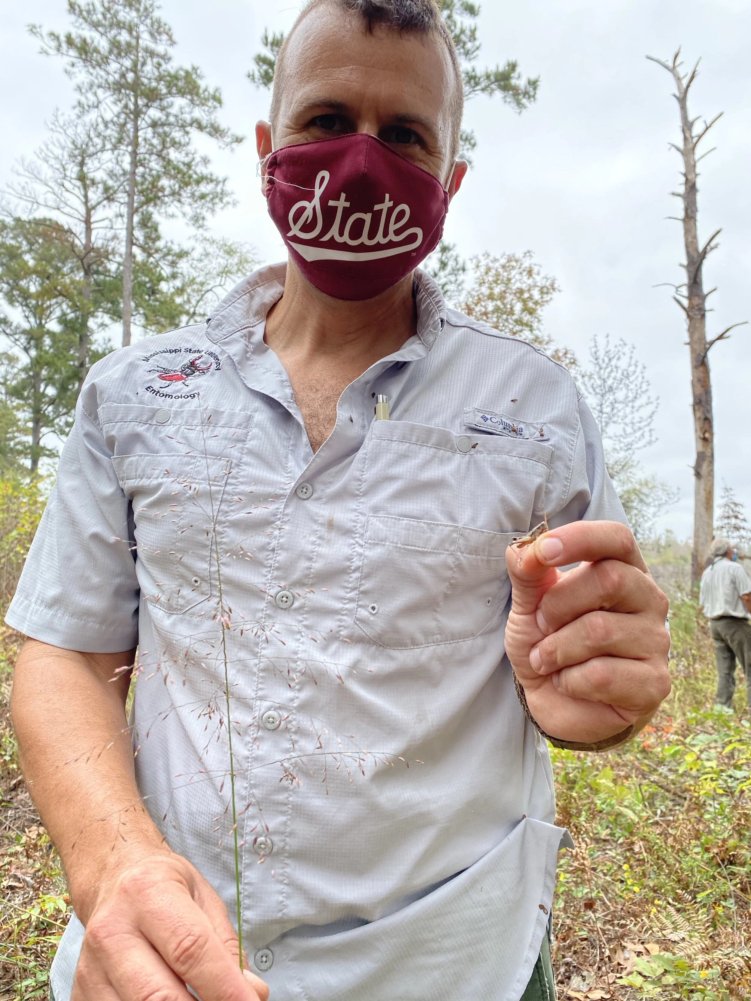
JoVonn Hill, Mississippi State University, shows a grasshopper in one hand and a rare grass, Chapman’s Purple Top, in the other.

JoVonn Hill prepares specimens of insects collected from prairies and savannas on the farm.

Close up of pinned grasshopper specimens collected during the first day of our visit to the farm.

Specimens like this one of Rattlesnake Master last for centuries and are stored in a plant museum called a herbarium. They serve as a permanent record of a species.
In addition to collecting physical specimens that will be permanently housed in regional museums and valuable for future scientific study, we will also document the species we find by uploading photos of them into the new “Biodiversity of Sumter Farm and Stock Company, Alabama” project on iNaturalist. SGI currently manages more than 70 iNaturalist projects across the Southeast. The beauty of iNaturalist is that it can serve as a great way for the farm owners and visitors to get in on the fun, to learn species, and to contribute to the biodiversity documentation aspect of this project.
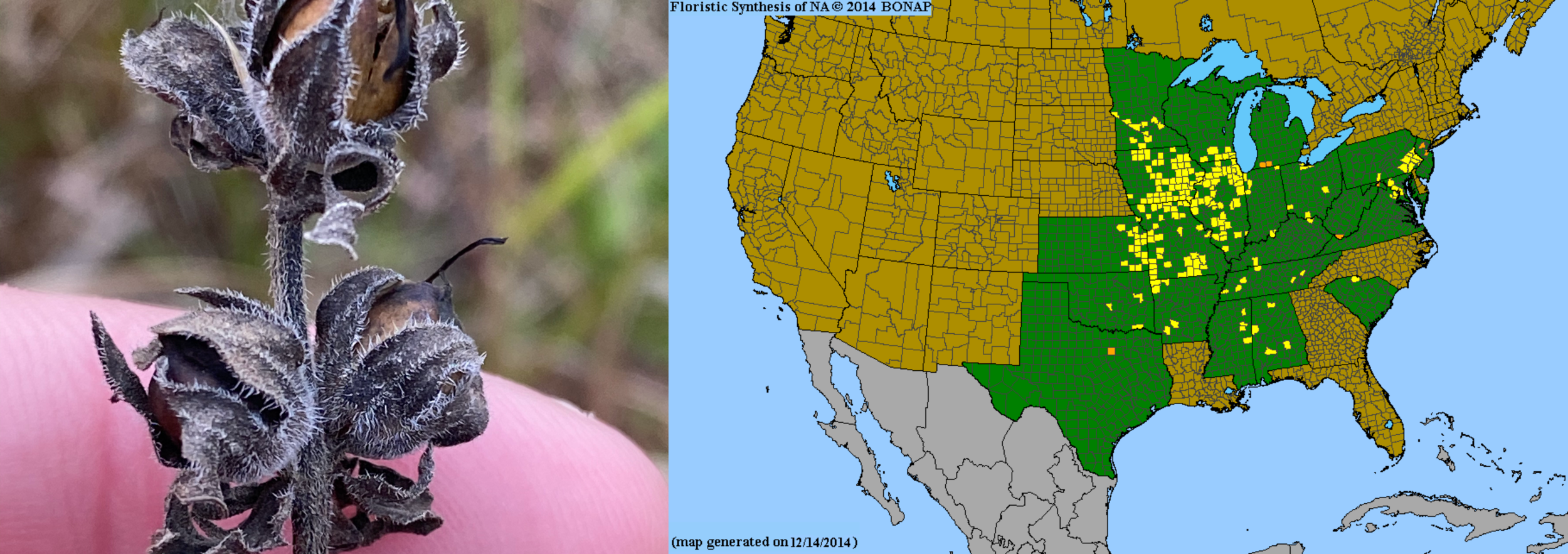
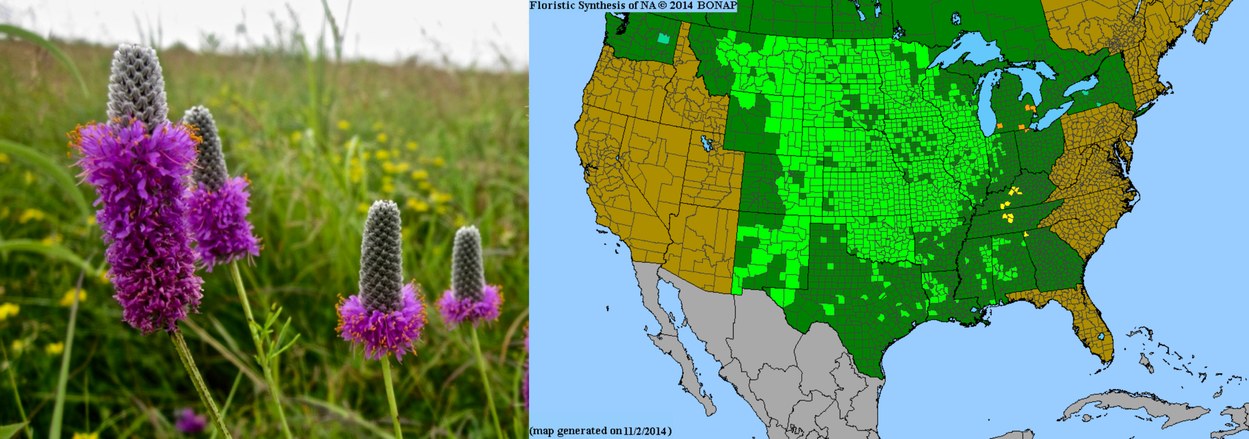
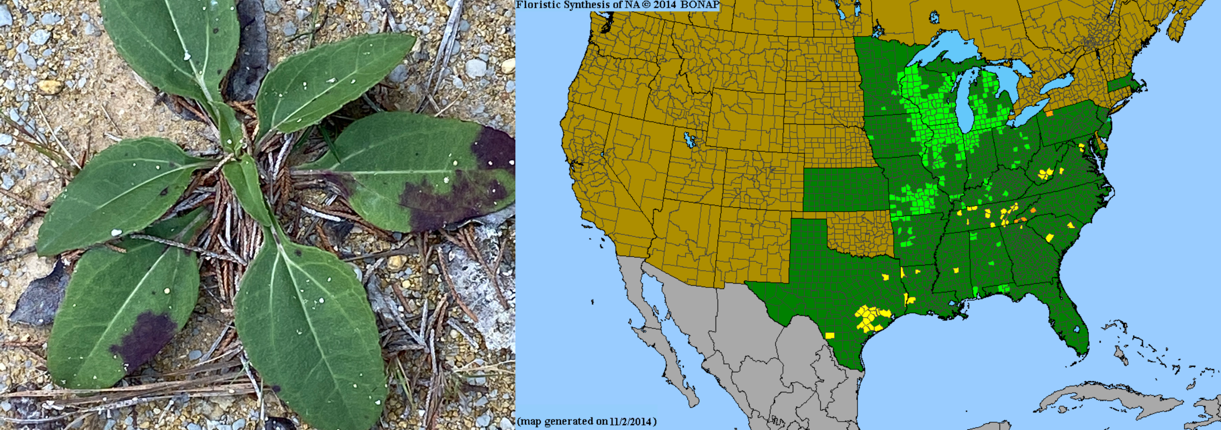
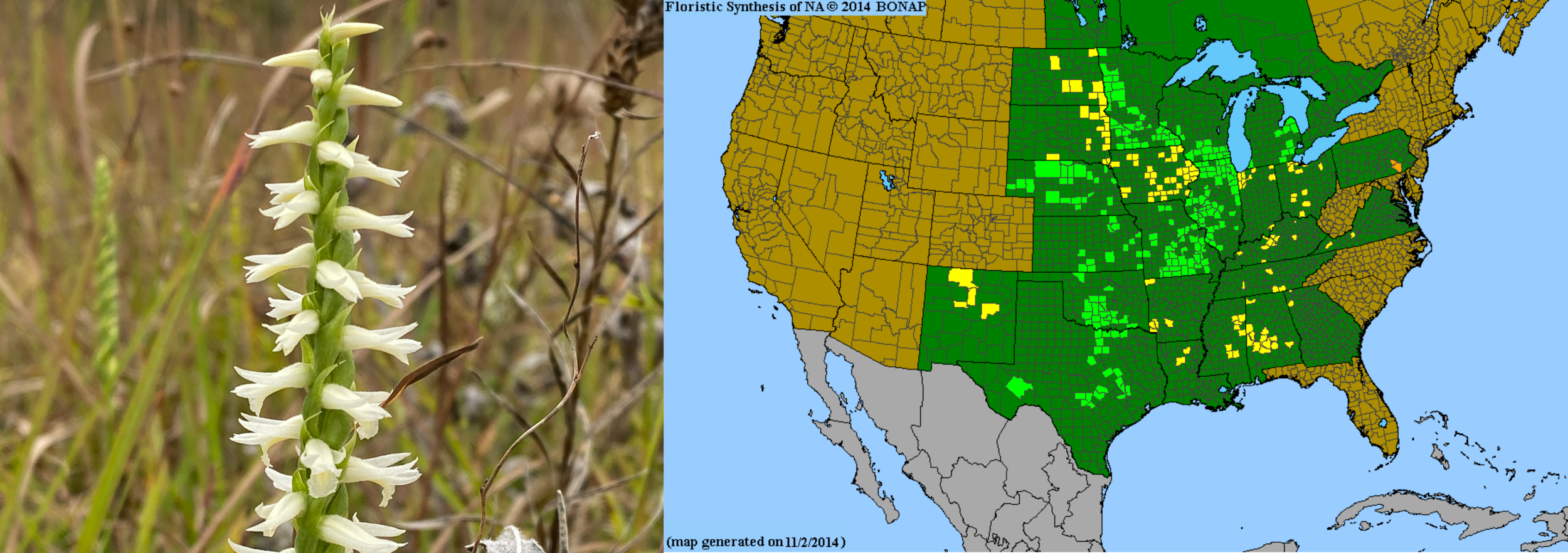
We will search for populations of rare species of plants and animals. During our two day survey we found multiple rare plant species, some of which are shown in the gallery below. These are all prairie species and many are rare or declining nationwide. In the maps below, counties in yellow indicate that the species is rare in that state, whereas orange counties indicate species that are considered to have been extirpated from that state.


The discovery of rare animals on the farm could aid in securing federal conservation dollars. During our two day survey, we observed suitable habitat for many additional rare species. Continued study could help to determine if these species are present. For example, in prairies and prairie woods we will search for such as the Small White Ladies Slipper Orchid (Cypripedium candidum) and Prairie Mole Cricket (Gryllotalpa major). In the mature loblolly pine savannas we will search for Red-Cockaded Woodpecker (Dryobates borealis). In hardwood forests and woodlands suitable habitat may exist for Indiana Bat (Myotis sodialis) or Northern Long-eared Bat (Myosotis septentrionalis) and other tree-roosting bats. On wooded bluffs suitable habitat for Price’s Potato Bean (Apios priceana) should be present. In the Noxubee River, several aquatic species could occur, including a number of mussels, Orangenacre Mucket (Lampsilis perovalis), Inflated Heelsplitter (Potamilus inflatus), Flat Pigtoe (Pleurobema marshalli), Heavy Pigtoe (Pleurobema taitianum), Ovate Clubshell (Pleurobema perovatum), Southern Clubshell (Pleurobema decisum), and Southern Combshell (Epioblasma penita).

Small White Ladies Slipper Orchid

Red-Cockaded Woodpecker

Prairie Mole Cricket

Prairie Pleatleaf

III. Develop Restoration, Management, & Conservation Plan
By combining habitat mapping with biodiversity documentation we can develop a “heat map” or “hotspot” map of areas on the Farm most suited to be managed, restored, and conserved. This will help to focus the farm’s resources where they are needed most and identify the priorities, timelines, and resources needed for use of fire, herbicide, selective logging, and seeding.
Ecological management and restoration can be tricky but having a thorough map of habitats and species survey are integral to conservation efforts. How often should a landowner burn and at what time of year? How many trees should be removed and which ones? Should seeds be brought in or is there an existing seed source on site such as a hidden seed bank or rootstock bank? Can cattle be used to help manage or restore grasslands effectively, and if so how? What invasive species are most problematic and are in need of eradication. Which ecosystems are we trying to restore and which should be prioritized?
A plan will help determine which areas are in most need of management with fire, how often to burn, and when to burn, and can help identify ways to get more fire on the ground.

A plan will help determine how to deal with noxious invasive species like the Sweet Tanglehead grass, discovered at the farm during our October visit. This grass was known primarily from south Alabama in the longleaf pine lands. This new find represents the northernmost known locality in Alabama and could be a problem in the future.

A plan can help determine if there are any areas that need to be restored with seeding, such as how SGI works with Roundstone Native Seed LLC to restore 50-acres of former soybean fields with Google in TN.

A plan will determine how best to manage for endangered species, such as the Earleaf False Foxglove. It will also help determine areas that can be used for conservation safeguarding, where rare species can be introduced via seed or plantings to create new populations, or rare animals can be introduced into suitable habitat.

IV. Tell an Untold Story of Cultural & Natural History
SGI is working to tell a remarkable story of the South’s “forgotten” grasslands and how their loss is tied to the fascinating and sometimes tragic story of American History. There may be numerous opportunities to explore this further with Sumter Farm & Cattle Co., much in the way that we currently are doing with Senator Bill & Tracy Frist in Virginia and Tennessee. This could include documentaries, joint research with historians, articles, etc.

V. Build Capacity for Regional Conservation in the Black Belt
SGI and our partners can band together with the Sumter Farm & Cattle Co. to bolster greater regional, state, and national support for the Black Belt in terms of conservation funding and support from private lands, government, philanthropic, corporate, and academic stakeholders. Future work could include workshops, symposia, land manager training, expanding conservation efforts with adjacent landowners and investors.
Timeline
Our work will take one year. For example, if we started June 1, 2021, we would need a project end date of May 31, 2022. The mapping efforts would be prioritized to get solid maps completed early in the project in order to inform the botanical and insect studies, as well as additional studies that might come later such as studies of birds, mammals, bats, reptiles and amphibians, etc. These maps are crucial to the development of the conservation and management plan.
The botanical and insect studies can begin concomitantly with the mapping effort but will continue after mapping has been completed. Project Manager, Theo Witsell, will also coordinate efforts by others interested in collecting data for the project such as project partners with USFWS, USDA NRCS, the family, etc. Data collected during these studies will help to refine maps and improve their accuracy.
A final report rich in photos, tables, and maps will be produced at the end of the project and submitted to the family, and to project partners (e.g. US Fish and Wildlife Service, USDA Natural Resources Conservation Service) for their review and input before completion of a final draft.
budget
The following budget breaks down the three components of our proposed work, describing and mapping habitat types, biodiversity surveys (plants and insects), and drafting a conservation, restoration, and management plan. This budget is broken down to show each element. These are working numbers based on our experience of what it will take to do the best quality work during a one-year period. Click on the budget image below to examine the budget in Google Sheets.
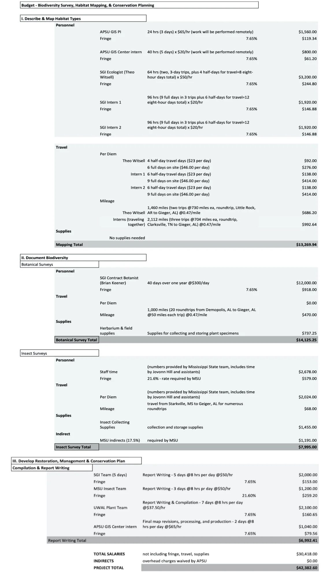
BUDGET JUSTIFICATION
PART 1 (MAPPING) — Mapping the 11,000-acre farm will require multiple steps and involvement of a team. This team consists of members who have expertise in ArcGIS (the industry standard mapping and geospatial analysis software for ecological mapping and natural resource management). All of SGI's ArcGIS mapping needs are managed by the APSU GIS Center staff and interns. Separately, we have SGI team members on the ground at the farm who have expertise in habitat delineation and data collection. The following is a brief overview of the mapping process. Steps 1-3 will occur in the first month of the project to ensure that preliminary maps guide the work of the larger team.
Step 1 – APSU GIS Center will assemble base maps (topography, geology, soils, aerial imagery shot at various dates, color-infrared aerial imagery (if available), LiDAR, etc.) along with other available map layers (wetlands, LANDFIRE [https://www.landfire.gov/vegetation.php], historical and cultural, roads, etc.) for the project and we will work with the Bell Family to ensure major features such as farm roads, trails, boundaries, cemeteries, structures and other interesting sites are included and accurate).
Step 2 -- APSU GIS Center will load data and base maps onto a password-protected ArcGIS Online project that can be shared with the family and with project partners as needed. This database will be used in the field via iPads/smartphones for field data collection and automated data uploads.
Step 3 -- SGI's science team, led by Chief Ecologist, Theo Witsell, will use their expertise to make a preliminary predictive map of the property that incorporates various base maps and our team's scientific expertise. For example, we will use the maps to define priority areas that need a high degree of focus. Study of aerial imagery will reveal likely prairie remnants. Study of LiDAR imagery will reveal past alterations of the ground surface as well as slight changes in ground elevation that can't be detected on topographic maps, and, if available for the area, tree canopy LiDAR can identify areas with the tallest tree canopies which may correspond with areas of oldest trees signifying possible old-growth forests, bat habitat, etc.
Step 4 -- In advance of field work we will digitally assign points to high priority survey areas, to ensure that we are covering representative areas of the farm and especially visiting important sites identified in Step 3. Our science team will then begin visiting these points across the farm to conduct "ground truthing." At each point, we will collect ecological data, make iNaturalist observations, and collect specimens.
Step 5 -- Once we complete "ground truthing" our combined GIS and science teams will reconcile our field-collected data with our various base maps to complete a final draft map. This will be made available to the Bell Family and project partners for input and recommendations.
PART II (PLANT & INSECT SURVEYS)
Plant Study: The botanical survey will take place over the course of one year. This includes time for Dr. Brian Keener, who is based locally, to visit the farm during 20 two-day trips (40 days throughout a one-year period). He would lead the work and would be joined periodically by students from University of West Alabama (UWAL) and other members of SGI’s science team who would visit less frequently to complete mapping. Under this approach, all plant species would be fully documented in a manner that would allow for publishing results in a scientific journal. This would include collection of an estimated 1,500 plant specimens that would be stored in the UWAL Herbarium and with duplicates of important species in the Austin Peay State University Herbarium. Brian will need some supplies to help process and store specimens which will be housed permanently after collection. Species would also be documented with photographs posted to the Farm's iNaturalist project. The mapping in Part I would help to inform this botanical portion of the study and likewise the botanical results would inform the mapping effort (Part II). For example, rare species of plants discovered during the botanical survey will be mapped, as will species that are indicator species for specialized habitats (such as prairie species in the understory of a cedar thicket suggests that removal of the thicket overstory would be in order to restore habitat). The mapping and botanical components would be used as the foundation for the conservation plan (Part III), as well as for guiding future animal-based research.
Insect Study: SGI will subcontract insect surveys to Dr. JoVonn Hill at the Mississippi Entomological Museum (MEM), also based locally, at nearby Mississippi State University. He and his team will conduct surveys for the prairie mole cricket, two endemic Black Belt beetles, and do comprehensive surveys for bees, butterflies, ants, and grasshoppers across all major plant community types. Their work will rely heavily on the maps produced for Part 1 of this project. They will need some supplies to help process and store specimens which will be housed permanently after collection in the MEM in Starkville, which represents the largest collection in the region and the third largest insect collection in the Southeast.
PART III (CONSERVATION & MANAGEMENT PLAN)
All of the data from the mapping, botanical inventory, and insect study will be combined into a final report. This report will be rich in photographs, tables, and maps and will serve as the foundation for guiding future land management and conservation actions on the farm. For example, it will help identify significant ecological areas (rare and/or high-quality natural communities, locations of populations of rare species, areas of critical wildlife habitat, etc.), and areas in need of active restoration and management (thinning of forest, woody plant control, prescribed fire, invasive species control, etc.). It will also help identify other key areas on the farm that may be underutilized for conservation, as well as those that are most appropriate for management focused on income generation. The report will also help identify potential funding needs as well as ideas for how to secure funding to achieve large-scale conservation goals.
PART IV (TELL AN UNTOLD STORY OF CULTURAL & NATURAL HISTORY)
Currently, our proposed work does not figure this into the budget. If it is of interest, then we can work with the family to explore ways to build this aspect. This could include pursuing opportunities for networking, video work, connecting with local historians and influential people, and exploring ways to incorporate conservation into the long-term plan for the farm.
PART V (BUILDING CAPACITY FOR REGIONAL BLACK BELT CONSERVATION)
SGI will be working on this through its own efforts but we encourage the family to join us in this effort. This could include reaching out to neighboring landowners, corporations, foundations, etc. to help build more support for local and regional conservation, both in on-the-ground action, in raising awareness, in garnering funding, in local and regional policy change, etc.
FRINGE BENEFITS
Fringe benefits are required to cover social security, FICA, medicaid for team members. It varies by institution, but ranges from 7.65% (APSU and UWAL) to about 21% for MSU.
OVERHEAD
Overhead fees (indirects) have been waved by for this project by Austin Peay State University, who will serve as project lead.